Wabash Heritage Trail (Tippecanoe Co. Parks)
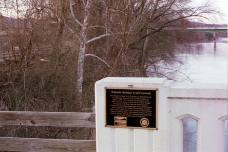
The Wabash Heritage Trail is a 13.0 mile trail starting on the north end at the Tippecanoe Battlefield in Battle Ground, IN (or as an alternate, Prophet’s Rock near Battle Ground, IN) and ending on the South end near Ft. Ouiatenon. The trail provides a nice hike thru a canopy of Sycamores, Oaks, Maples, Cottonwoods with a variety ofwildlife including numerous birds (including heron, eagles, owls, ducks …), deer, raccoons, beavers, squirrels, rabbits, chipmunks, etc. Trail maps and conditions are available at the Wah-ba-shik-a Nature Center at the Tippecanoe Battlefield in Battle Ground, IN or by calling 765-567-6218. The complete trail with all of its spurs covers about 17 miles. With the start of the trail at the Tippecanoe Battlefield of Prophet’s Rock the trail goes southwest along and crosses Burnett’s Creek, named for early white settler and trader, Frenchman William Burnett. As the trail continues to the 3.6 mile mark, you reach the site of the historic Davis Ferry, where John Davis established his ferry business in 1823. Crossing the Wabash River, you travel along the Wabash past Heron Island, a 12-acre wildlifepreserve and heron rookery accessible by boat. At about the 5 mile mark there is a rest stop with a picnic table and views of the Wabash. The trailcontinues under the Sagamore Parkway (US-52) overpass and then along the old abandon Municipal Golf Course, part of McAllister Park. At the 6.5 mile mark a paved spur of the trail leads up to North 9thStreet and an additional access, parking point. As the trail continues into Lafayette, you arrive at Riehle Plaza and cross the Wabash River on the John T. Myers Pedestrian Bridge (at the 8 mile mark) into WestLafayette and Tapawingo Park. From Tapawingo Park the trail can be taken North or South. To the North the trail goes to the Wabash Heritage Trail Overlook on the old Brown Strreet Bridge abutment, built in 1857 as the first bridge built between the City of Lafayette and Village of Chauncey (becoming West Lafayette). Continuing further Northwest the trail passes thru Happy Hollow Park to both Rose Street and Indian Trail Drive. From Tapawingo Park the trail also goes southwest, with spurs to Tapawingo Drive and South River Road. The main part of the trail takes you southwest along the Wabash River to near Ft. Quiatenon at the 13 mile mark (the last part of the trail forces you up to South River Road to complete the trip). Along the trial there are parking access points at Tippecanoe Battlefield, Davis Ferry, McAllister Park (old Municipal Golf Course), Riehle Plaza, Tapawingo Park, Happy Hollow Park and Fort Ouiatenon. There are public restrooms at Tippecanoe Battlefield, Riehle Plaza, Happy Hollow Park, Lyboult Sports Complex and Fort Ouiatenon.