This joint 279 acre property includes the 179 acre Weiler-Leopold Nature Reserve and the 100 acre Black Rock Barrens Heischman-McAdams Reserve. There are 2 loop trails for this shared parking area at the edge of the woods. An additional large loop trail, around the previous bottomland farmland that was reforested in 2001 with native oaks and hickories, provides a total of 4 miles of hiking pleasure from the three loop trails.
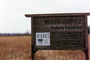
The 179 acre Weiler – Leopold Nature Reserve features the Ron Bogaard Nature Trail (sponsored by Sycamore Audubon Society). This loop trail is the one on the right heading southwest out of the parking lot. The trail features 4 distinct areas. The trail begins in a restored high grasslands prairie with various native wildflowers. Be sure to watch for informational plant species signs found along the trail. The second part of this loop trail winds thru a wooded area previously used for grazing, the trail brochures found at the trailhead provide information on the evolution of this type of ecosystem. The trail then turns back northeast thru black rock slopes and past a wet meadow. The fourth mini-ecosystem is an open oak woodland along the ridges and ravines with all the usual under canopy grow and wildlife.
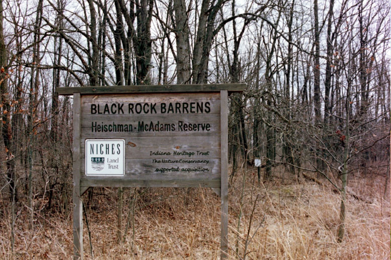
The 100 acre Black Rock Barrens property to the east of Weiler – Leopold is a State Nature Preserve as it harbors an excellent example of a siltstone glade ecosystem community which is rare in the Midwest. As a State Nature Preserve care must be taken not to collect or damage any plant, wildlife or material on the property without prior permit from NICHES and the Indiana Division of Nature Preserves. The trail leaves the joint parking area to the left (southeast). Various mini-ecosystems are featured in the trailhead NICHES brochures for this trail. As you start out on the trail you are in a mature white oak forest. You progress thru an area with thin soils over siltstone bedrock produces an interesting plant community. As you descend down to the river bottom area you transverse a deep ravine originally cut by the rushing waters of the melting glaciers 10,000 years ago. Along the bottomland boundary you will travel thru a sugar ample area undergoing thinning management and then to a more moist area from slope runoff and ground seepage that allows for yet another type of ecosystem to flourish.
The mixed ecosystems of the three loop trails provide a variety of bird and wildlife viewing opportunities.
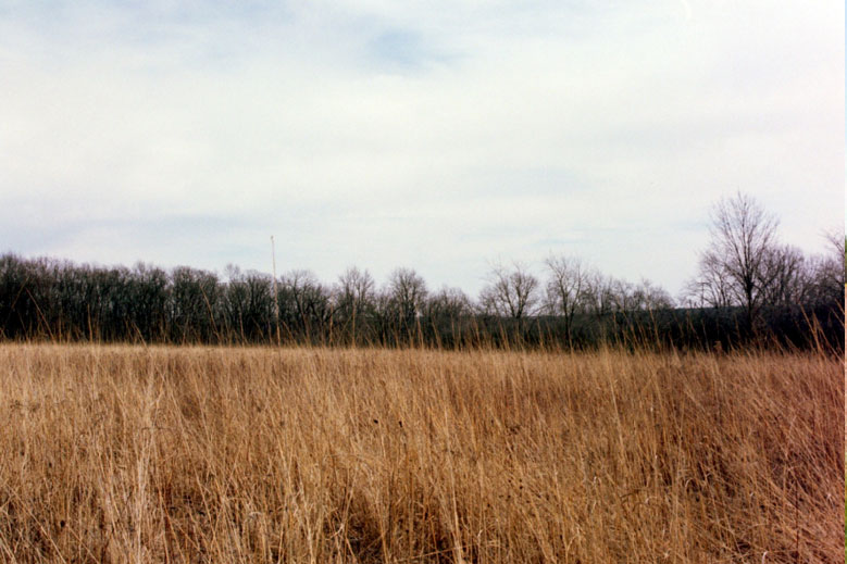
Weiler – Leopold Meadow
These are foot traffic only trails and as NICHES Land Trust properties the usual NICHES restrictions apply including:
- No camping
- No campfires
- No glass containers
- No vehicles or ATV’s on the preserves, except in designated parking areas ONLY
- No hunting without prior written permission as part of controlled population control
- Dog must be kept on a leash (6’ or less in length)
- No property modifications
- Follow the “leave no trace” philosophy
 Directions from the intersection of US-231 and South River Road near West Lafayette, IN
Head west on South River Road. You will be following this road for 10.3 miles before the next turn.
Along the way you will see Fort Quiatenon at the 2.4 mile mark.
At the 3.9 mile mark, continuing straight, the road becomes Division Road.
At the 4.0 mile mark, you will cross Jordan Creek.
At the 6.4 mile mark, you will cross the intersection of CR 700 W (Granville Bridge Road).
At the 6.5 mile mark, you will see the turn off for the Tippecanoe Parks – Granville Access.
At the 6.7 mile mark, you cross Indian Creek.
 After winding up Indian Hill, at 8.0 miles you will travel beside the Ravines Golf Course.
At 9.4 miles the road surface changes (still paved) as you cross the Tippecanoe County –
Fountain County line and the road name changes to 700 N.
At 9.8 miles the road makes a 90 degree turn south (left) and becomes 1150 E.
At 10.0 miles the road turns back west (right) and becomes 675 N.
At 10.3 miles you need to turn before entering Greenhill (see directions below).
At CR 1125 E in Fountain County (just before you enter the small town of Greenhill) turn left (south).
(You will be traveling south and west on Independence Road, so named as it eventually ends in Independence, IN.)
After 1.7 miles 1125 E turns right (west) becoming 500 N.
After 0.25 miles you are forced to turn back south (left) as the road becomes 1100 E.
After 2.0 miles the road turns right (west) and you travel alongside the woods for 0.2 miles to the parking area on your left at the edge of the woods. (You are on the north side of the properties.)
Your total traveling distance from the start at the US-231 and South River Road intersection is 14.45 miles.
These two properties share a parking area.
Directions from Attica (from traffic light at intersection of S. Perry St and Jackson St (IN-28,IN-55, US-41)
Head north on S. Perry St toward downtown Attica.
After 0.1 miles S. Perry St becomes N. Perry St at the 4-way stop at the Central National Bank corner.
Continue straight on N. Perry St.
At the 0.2 mile mark the N. Perry St angles northeast
At the 0.5 mile mark you cross the railroad tracks
At the 0.9 mile mark N. Perry St becomes E. River Rd at the city limits
At the 4.9 mile mark you reach the intersection of E. River Rd and Riverside Rd
Turn left (north) onto Riverside Rd traveling 0.7 miles across the Wabash River bridge to Independence Rd
(Crossing the Wabash River takes you from Riverside, IN to Independence, IN and the road name
Changes to Cicott Rd)
Turn right (east) onto Independence Rd (the Old Fashioned United Baptist Church is on the corner)
Travel 3.3 miles to the Weiler – Leopold Nature Preserve / Black Rock Barrens parking area on the right
(Along the way you will travel past Cicott Park on the right in Independence, at the 1.6 mile mark
thru the intersection with 950 E, at 2.2 miles you cross a small bridge at the intersection of Buffalo Hill Rd, for the next mile winding northeast beside the NICHES Land Trust property you will see bottomland, reforestation, older woodlands and finally grasslands reaching the Weiler – Leopold/
Black Rock Barrens parking area on the right at the 3.3 mile mark.)
Directions from Lafayette and southwestern areas of Tippecanoe County
From the intersection of US -231 and IN-25 travel west and south on IN-25 thru Shadeland and West Point
At 12.4 miles just past the jog in road for Odell, IN turn right (west) toward Attica on IN-28.
(This is the second junction with IN-28; the first goes east to Romney, the second west to Attica.)
Travel west 4.8 miles on IN-28 to Riverside Rd.
At the 0.9 mile mark you cross the Tippecanoe – Fountain County line
At the 3.9 mile mark you pass thru the IN-28 & IN-341 intersection
At the 4.8 mile mark turn, see below
Turn right (north) on Riverside Rd toward Riverside, IN & Independence, IN
Travel 3.8 miles north to Independence, IN
Along the way you travel thru a 4-way stop at the 0.9 mile mark
At the 2.2 mile mark the road starts downhill into the Wabash valley.
At the 3.1 mile mark you pass straight thru a 4-way stop and cross the railroad tracks in Riverside.
At the 3.7 mile mark you cross the Wabash River, thus entering Warren County, you leave the town
of Riverside and enter Independence, and the road name changes from Riverside Rd to
Cicott Rd
At the 3.8 mile mark, just after crossing the river you will turn right (east) at the 4-way stop onto
Independence Rd, the Old Fashioned United Baptist Church is on the corner in front of you.
Travel on Independence Rd for 3.3 miles to the Weiler – Leopold Nature Preserve / Black Rock Barrens
parking area on the right
(Along the way you will travel past Cicott Park on the right in Independence, at the 1.6 mile mark
thru the intersection with 950 E, at 2.2 miles you cross a small bridge at the intersection of Buffalo Hill Rd, for the next mile winding northeast beside the NICHES Land Trust property you will see bottomland, reforestation, older woodlands and finally grasslands reaching the Weiler – Leopold/
Black Rock Barrens parking area on the right at the 3.3 mile mark.)